Services
Geotech Provides a Full Range of Services
Customer Support
Geotech offers a variety of services to help customers learn about and solve their technical and business problems. In over thirty years in the business, we have seen many different problems and helped solve them. And if we can't help you, we'll help you find someone who can. We also maintain a list of Frequently Asked Questions (FAQs) on this website.
Our customers can reach us with their software problems either by calling us toll-free at 877-740-1999 or Contact Us.
See what one of our customers had to say about the service provided by one of our customer support staff:
"I just wanted to take a second to express my gratitude for the support that Russ has provided to us. He is always extremely timely, and proactive on solving issues." - Michael Mejac, Data/GIS Manager, Natural Resource Technology, Inc.
To learn more about Geotech's training programs and seminars, call toll-free 877-740-1999 or contact us at info@geotech.com.
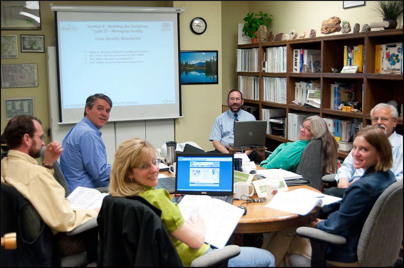
Training
Geotech provides both training both specific to our commercial software for our customers, and also general training to the environmental industry on environmental data management concepts and practices.
Although Geotech's software is easy to use, we do strongly recommend training for first time users. These services can be obtained directly from Geotech. Training can also be very helpful for those wishing to perform their own customization work. Training classes can be presented at your location, Geotech's office in Colorado, or via web presentation.
Our industry training is offered in conjunction with various conventions and conferences. You can see examples of our free documents and seminars here.
Data Loading
Geotech can provide data loading services for our clients, starting with either hard-copy or digital data in a variety of formats, and resulting in a coherent, accurate data set. One example is a data conversion that we did for a medium-sized consulting company on an aging in-house database that was poorly designed and not a good fit to the company's business needs. Geotech migrated 20,000 records, overcoming a poor data normailzation design in the process, in less than a day. On another, much larger project, we migrated over twenty years of data for a major steel plant, over two million records, from two large databases and hundreds of lab files into one consistent database in a week and a half.
Customized Development to Meet Your Needs
Geotech sells the best environmental data management and GIS software in the industry. But we also have over 30 years of experience helping clients with custom solutions that may not fit any off-the-shelf software.
Custom Development
Enviro Data and Enviro Spase are intended to be flexible and configurable to handle most any data you need to manage. However, if you need something special, Geotech can customize the Enviro software to meet your company's specific business needs for managing your data. For some examples of projects that Geotech has done for clients over the years, visit our Example Projects page.
Custom Programming
Our staff and consultants can provide a variety of programming and other software services. Because of our extensive experience in working with databases to manage spatial (map) and other data, we will design/redesign your company's database so you can better manage your data and access it spatially.
Geotech sells the best environmental data management and GIS software in the industry. But we also have over 30 years of experience helping clients with solutions that may not fit any off-the-shelf software.
Other Services
Sometimes your requirements may not fit into any of the above categories. That's when you need to talk to someone who has enough experience and creativity to structure just the right combination of service and technology to meet your needs. If this is your situation, contact Geotech!
The Enviro software suite from Geotech Computer Systems brings powerful yet affordable environmental data management and display to your desktop. From planning your sample events to creating tables and maps, professional-grade tools help you save time and money, and improve quality, on your projects. Enviro Data stores and displays environmental quality data, such as field and laboratory data for water and soil. Data storage can be in Access, SQL Server, or Oracle. Enviro Spase builds on the strong interface between Enviro Data and ArcGIS, and runs within ArcGIS. It helps you display your environmental data on GIS maps.
Contamination Plume Tracking using Geotech's Software
A good example of our service capabilities is illustrated by a plume animation video. This animation shows movement of a plume of contamination from a point source, moving down a hillside over time. It was created using Enviro Data, a modeling program, and animation software.
Contact Us
Phone: (877) 740-1999 or (303) 740-1999
EMail: info@geotech.com
© 1995- 2023 Geotech Computer Systems, Inc.
Header photos by Dave Rich